Tokyo Transit: A Complete Guide
Video's Narrative
Tokyo Transit: A Complete Guide
Navigating a foreign city can be daunting, but few places pose more challenges than Tokyo. A maze of Tokyo’s transportation network awaits here - the lines and stations sprawl before you.
This, combined with language and cultural differences, can make planning a trip to Japan seem overwhelming. But don’t worry! We’re here to guide you through the complexities. Join us as we unravel the secrets to a stress-free Japan trip.
Japan’s public transportation system is exceptionally well-developed, and using it wisely is indispensable for enjoying your trip. Although it can be challenging to navigate, mastering the public transit system is key to successful travel, helping you maximize your valuable time and minimize costs.
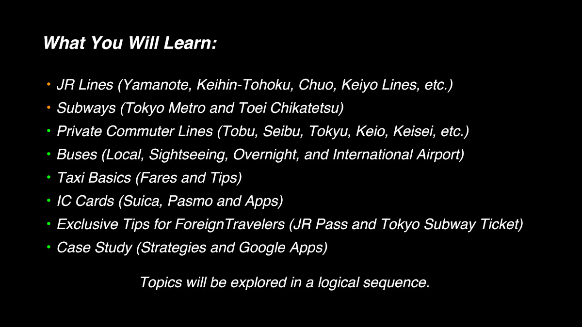
We'll start by breaking down the basics of Tokyo's train and subway systems, followed by expert tips on navigating the city like a local using Google Maps. Our primary focus is on JR and subway lines within downtown Tokyo, but we'll also cover private commuter lines, buses, and taxis for a comprehensive guide. Additionally, we'll explain how to use transportation IC cards and offer exclusive advice for international visitors.
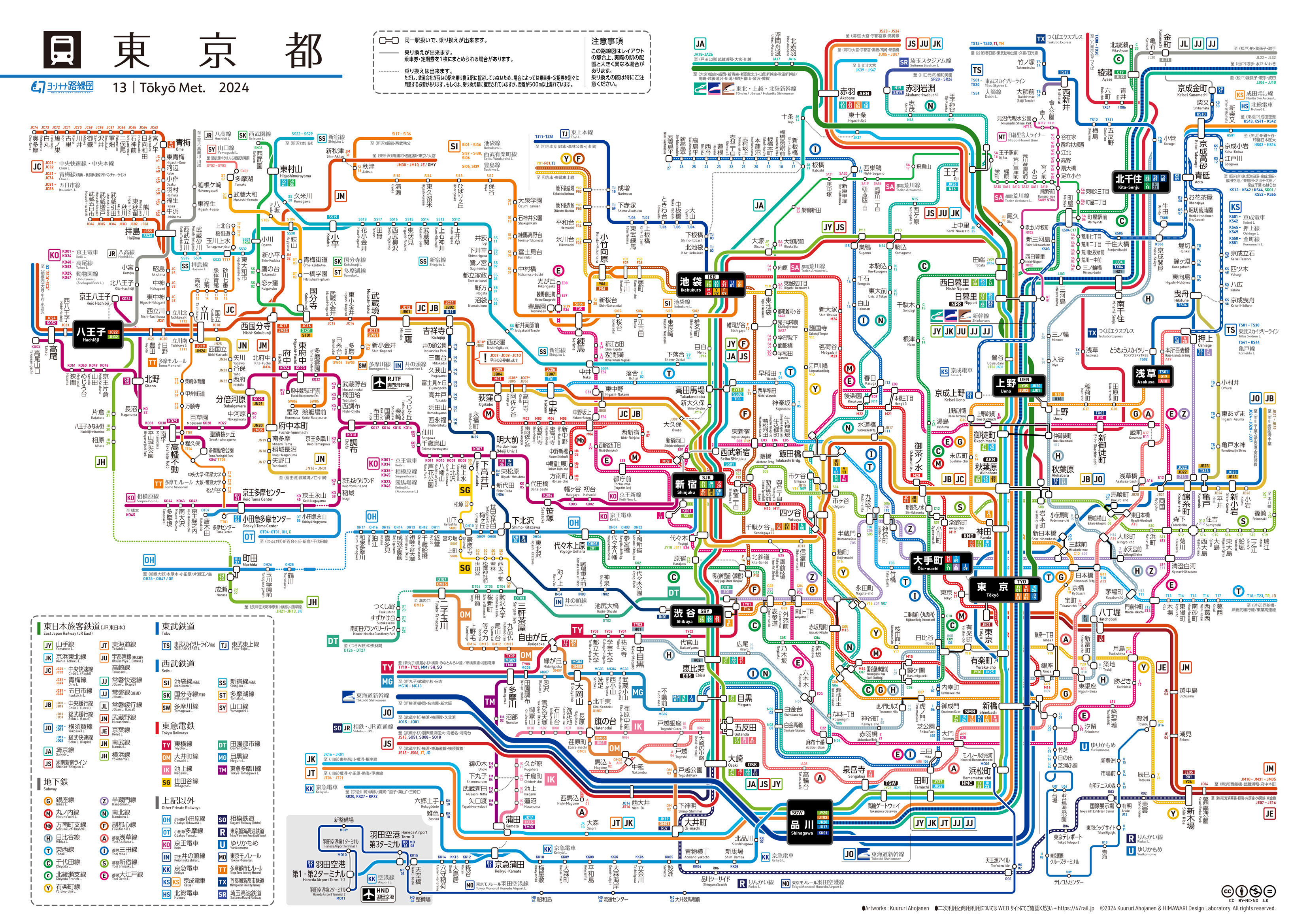
Let’s take a look at the transportation network map again. It is important to note that the network consists of three segments: 1) JR Lines, 2) Private Lines, and 3) Subway Lines - although 2 and 3 are broken down further.
For those unfamiliar, JR stands for Japan Railways. It used to be a national government organization but was privatized in 1987. A group of JR companies formed, and today, they operate most of Japan’s rail services. JR lines are crucial for traveling across Japan, known for their efficiency and punctuality. In Tokyo, JR lines like the Yamanote Line connect major districts and are integral to the city’s public transit system.
Additionally, JR companies operate the Shinkansen, Japan's renowned high-speed bullet train, which is ideal for traveling across the nation. The fastest Shinkansen connects Tokyo and Kyoto, covering approximately 450 km (280 miles) in just 2 hours and 15 minutes. Tokyo Station is the hub of the Shinkansen lines, serving as the primary departure point for high-speed journeys to various destinations across Japan.
Also, JR East operates the Narita Express (N'EX), a direct train service connecting Narita Airport with major Tokyo stations such as Tokyo, Shinjuku, Shinagawa, and Yokohama. It’s a convenient option for travelers looking to reach the city quickly and comfortably from the airport.
Non-JR lines, including private commuter lines and subways, complement the JR network. Commuter lines like Tobu, Seibu, and Tokyu extend to suburban areas, while subways like Tokyo Metro and Toei Chikatetsu primarily serve downtown areas, enhancing the overall coverage of Tokyo's transportation system. Together, these lines form an extensive network, creating an intricate and detailed route map as shown.
As a first step, you must understand how to ride a train or subway in Japan. You enter the station’s fare zone through a ticket gate and proceed to the platform of the line for your destination. This requires a physical ticket or IC card to pass through the gates. You also need a ticket or IC card to exit from the fare zone. Small tickets are used for short rides, while larger tickets are often used for long distances. IC cards like Suica and Pasmo, or smartphones with those apps, are commonly used for short rides in Tokyo and the surrounding areas. In Osaka, you'll find a similar card called 'ICOCA,' but you can use these cards interchangeably throughout Japan.
While some still purchase individual tickets for each trip, this is generally for long-distance travel. Many locals use IC cards for daily rides, though recently, some have opted for smartphone apps to streamline their travel. You may do the same as it is relatively easy. Notably, ticket machines and gates operate similarly across JR, subway, and private railway lines, making the process intuitive.
While the combined map of JR, private, and subway lines must have appeared overwhelming, the Tokyo Metro map, focusing solely on subway lines and the Yamanote Line, offers a more manageable overview of the city's core transportation network.
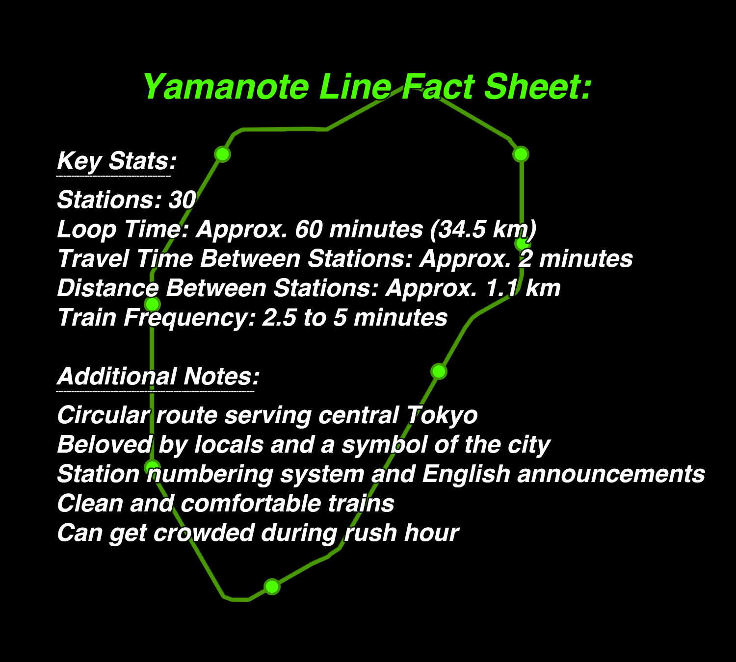
It serves central Tokyo with a 35km loop containing 30 stations in approximately 60 minutes.
Take a look at another route map. While these maps effectively show routes and station connections, they are not drawn to scale. As a result, comparing distances between routes based on the maps can be inaccurate. This map particularly distorts the shape of the Yamanote Line loop. Nonetheless, it is helpful for quickly identifying relative relations of lines and stations.
Imagine you're in Ginza, Tokyo's upscale shopping and entertainment district, and you want to head to Shibuya, known for its iconic scramble crossing and vibrant nightlife. You have several route options, each with varying transfers and travel times. Google Maps will guide you through which trains or subways to take, where to transfer, and how long each journey will take based on your exact location and the time of day.
As you search for directions, Google Maps suggests taking the Ginza Line via Ginza Station as the quickest and most cost-effective option, with an estimated travel time of 22 minutes. Alternatively, it offers the route of riding the JR Yamanote Line via Shinbashi Station, with an estimated travel time of 32 minutes. Keep in mind that these times include times to walk to each station, and they can vary depending on train availability and other factors at the time of travel.
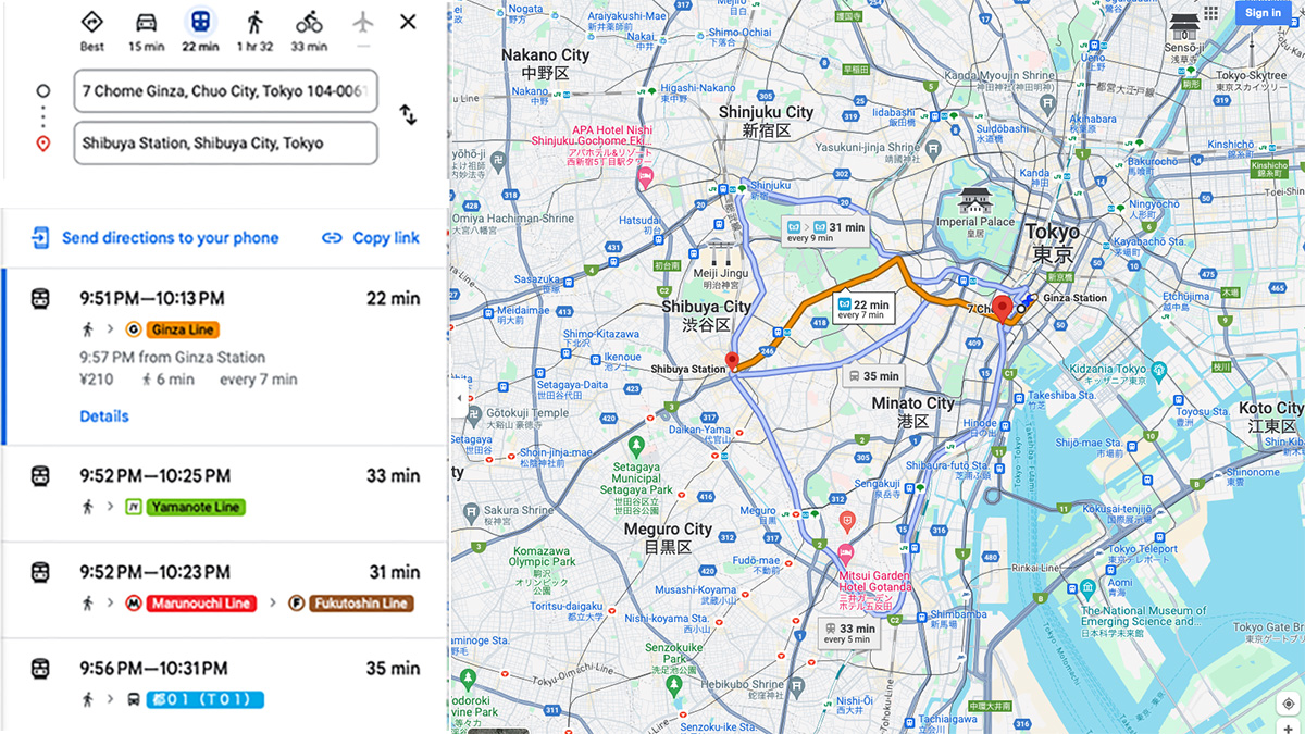
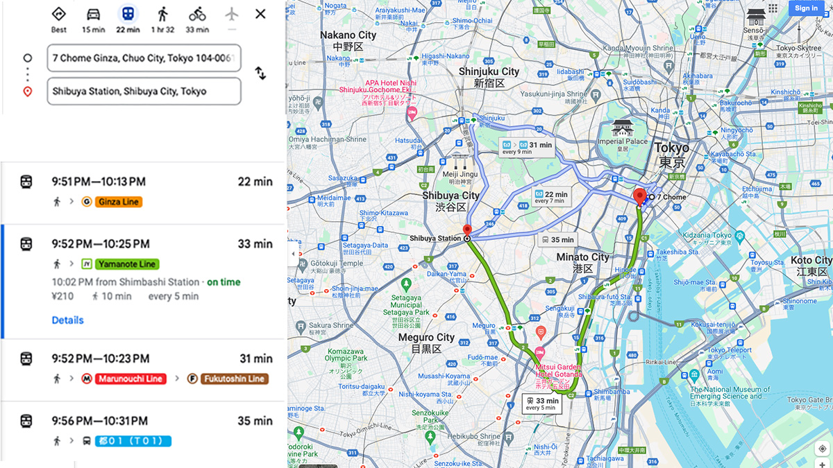
If you’re uncertain about navigating the subway system, the JR Yamanote Line route is a reliable alternative. While it might not be the fastest or cheapest choice, the time and cost differences compared to subway routes are generally minimal. In this example, neither option requires transfers, but it’s generally a good practice to prioritize routes with minimal transfers to make your trip smoother.
Yamanote Line is easy to understand and convenient, and we recommend using it whenever possible. Nonetheless, using the Yamanote Line can sometimes become inefficient, resulting in more time and cost.
For instance, if you want to visit Asakusa Senso-ji temple, the nearest JR station is Ueno Station, which is about 2 km away. As you can easily reach Asakusa by taking the Tokyo Metro Ginza Line from Ueno, you might consider using the Yamanote Line to Ueno and then transferring to the subway to Asakusa. However, this plan makes your trip a gate-transfer ride. In fact, you’ll find two subway stations in Asakusa—both close to Senso-ji. In many places in Tokyo, subway stations that take you to Asakusa without gate transfers are available. For example, if you are in Shinbashi, Ginza, or Kanda, either the Ginza Line or Asakusa Line takes you to Asakusa without transfer. Do not take the Yamanote Line in such cases. When comparing these three options for the Shinbashi to Asakusa trip, you'll notice significant differences in both travel time and cost. The option involving a gate transfer is the slowest and most expensive.
Here is the comparison. What do you think? For those who purchased a JR Pass—a special pass for foreign visitors offering unlimited travel on JR trains across Japan, including the Yamanote Line—the cost of the last option becomes cheaper. Nevertheless, despite the reduced cost, the time and complexity of the trip remain less favorable. Therefore, we recommend opting for the first or second option for a more efficient journey.
Let me explain exclusive tips for international travelers now. Please pause the video to read the upcoming summary sheets if you want details. First, the JR Pass offers unique advantages for international visitors. The JR Pass provides unlimited travel on JR lines nationwide, including the Yamanote Line, making it ideal for those exploring multiple regions by Shinkansen. Second, the Tokyo Subway Ticket: This ticket offers unlimited travel on the entire Tokyo subway system, often providing a more efficient and cost-effective option for navigating the city.
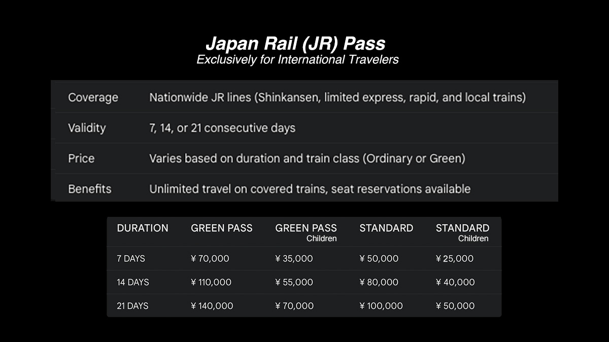
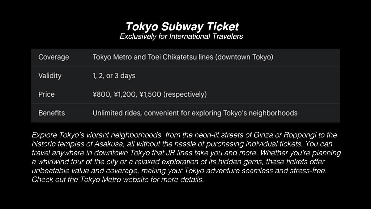
Both the JR Pass and Tokyo Subway Ticket offer exceptional value for international travelers, each catering to different travel styles. However, it's essential to consider your travel plans carefully, as these passes may not be the most cost-effective option for all visitors.
Understanding how to navigate both subways and JR lines can enhance your travel experience and provide more options for getting around.
Now, let’s explore the interconnection of subway lines in downtown Tokyo. Take Tokyo Station and Otemachi Station as an example—they are just about 500 meters (0.3 miles) apart. Depending on your walking speed and route, walking between these two stations usually takes 5 to 10 minutes. An underground passage connects them, offering a convenient, weather-sheltered route. In general, if two stations on the map appear to be as close as Tokyo and Otemachi Stations, you can expect a similar walking time of 5 to 10 minutes between them.
Subway systems offer numerous advantages, including speed, efficiency, and coverage of urban areas. However, one significant challenge is locating subway entrances. Often small and discreet, they can be difficult to spot from street level, potentially causing inconvenience for passengers, especially first-time visitors.
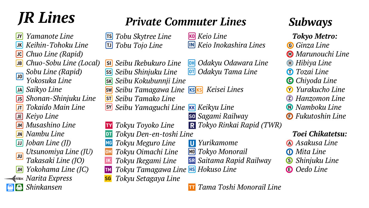
Japan's rail lines are labeled alphabetically. JR lines, for example, use an alphanumeric code with 'J' followed by another letter. The Yamanote Line is 'JY,' while the Keihin-Tohoku Line is 'JK,' the Chuo Line is 'JC,' and the Keiyo Line is 'J E.' There are 16 such JR lines in Metropolitan Tokyo. Similarly, private commuter lines and subway lines also use alphanumeric codes, making navigation easier, as shown on the list.
Additionally, the station numbering system aids in navigation. For instance, on the Yamanote Line, stations are labeled with a combination of letters and numbers, such as 'JY01' for Tokyo Station. The numbering increases counter-clockwise from Tokyo Station's 'JY01' to 'JY03' for Akihabara, 'JY05' for Ueno, 'JY13' for Ikebukuro, 'JY17' for Shinjuku, 'JY20' for Shibuya, and 'JY30' for Yurakucho, which is the last station before completing the loop. The numbering system also proves helpful as English announcements often include station numbers, making it easier to identify stops.
Beyond central Tokyo, the Keihin-Tohoku Line (JK) extends south to Yokohama and north to Urawa and Omiya, complementing the Yamanote Line. Between Shinagawa and Tabata, the JK Line runs parallel to the Yamanote Line and shares platforms with Tokyo Station labeled JK26. The station numbers on the JK Line increase as you travel north. If your trip is between Shinagawa (JK20) and Tabata (JK34), you can use either the Yamanote Line or the Keihin-Tohoku Line.
The Chuo Line (JC) is a key east-west route connecting Tokyo Station with the western suburbs, including Takao. It is useful for traveling from Tokyo Station to Shinjuku. For Disney enthusiasts, the Keiyo Line (J E) is vital, providing direct access to Maihama, where Tokyo Disneyland and Tokyo DisneySea are located.
Would you happen to have a better picture of the Tokyo transportation network now? Transfers between JR Lines are non-gate-transfer, meaning you do not have to pass through additional ticket gates, but if you transfer from JR lines to subway lines, you need to pass through ticket gates.
Now, let me explain the subways in Tokyo in more detail. There are two major subway systems: Tokyo Metro and Toei Chikatetsu.
Tokyo Metro operates the majority of the subway lines in Tokyo, covering a large portion of the city. Known for its efficiency and extensive network, Tokyo Metro lines are labeled alphabetically with a combination of letters and numbers, such as the Ginza Line (labeled G) and the Marunouchi Line (M).
Toei Chikatetsu, operated by the Tokyo Metropolitan Bureau of Transportation, runs several subway lines that complement the Tokyo Metro system. Toei lines include the Asakusa Line (labeled A) and the Oedo Line (E). These lines are especially useful for accessing areas not covered by Tokyo Metro and for traveling within Tokyo's 23 wards.
Both Tokyo Metro and Toei Chikatetsu lines use a numbering system similar to JR Lines, where numbers increase sequentially along the line. For example, on the Ginza Line, the numbering starts at Shibuya Station (G01) and ends at Asakusa Station (G19).
Each system has its own fare zones and ticketing, so transfers between Tokyo Metro and Toei Chikatetsu lines involve 'gate transfers' that require passing through different ticket gates. Generally, such trips, including ‘gate transfers,’ are more complicated and expensive.
Another system you need to know about is private commuter lines. Tobu, Seibu, Tokyu, Odakyu, Keio, Kay-say, and Kay-kyu. These major transportation companies operate multiple commuter lines, each serving different regions and providing important connections to areas beyond the core Tokyo network. These private lines complement the JR and subway systems, expanding Tokyo’s transportation network’s overall reach and flexibility.
Now, let's explore the accessibility of three major stations along the Yamanote Line: Shinjuku, Shibuya, and Ikebukuro. Each summary will detail their connecting lines and key destinations.
While Tokyo's extensive train and subway networks cover most of the city, bus services offer additional flexibility, especially for reaching neighborhoods not directly served by rail lines. The Toei Bus, commonly known as To-bus, is the primary municipal service. It connects various parts of Tokyo, including tourist spots and residential areas, offering a convenient option for short-distance travel. Private bus companies like Tokyu Bus, Odakyu Bus, and Keio Bus also operate routes that complement the subway and train networks, serving both urban and suburban areas.
Bus fares in Tokyo are generally flat-rate, ranging from 210 to 240 yen, and payment is easy with IC cards like Suica or Pasmo. Exploring Tokyo by bus also offers a unique perspective, allowing you to enjoy scenic views not visible from the subway. Google Maps frequently includes bus routes in its recommendations, simplifying the process of finding the best bus option for your journey.
Additionally, some bus services, such as Hato Bus, provide tours to popular Tokyo destinations and places like Mt. Fuji. These services allow you to explore iconic sights without the hassle of navigating trains or arranging transportation, making your travel experience seamless and enjoyable.
Also, long-distance bus services, often called "overnight buses" or "sleeping buses," are popular and cost-effective travel options in Japan. They provide an affordable way to travel between major cities and regions while saving on accommodation costs.
Lastly, bus services offer an economical and convenient option for travelers heading to Narita or Haneda Airport or vice versa. Although travel time to Narita may extend to 90 minutes or more depending on traffic and your location in downtown Tokyo, various companies provide flexibility in choosing departure and arrival points beyond Tokyo Station. Such bus services are available from multiple locations in Tokyo, including Tokyo Station, Shinjuku Station, and the T-CAT Bus Terminal in Hakozaki.
The T-CAT (Tokyo City Air Terminal) offers a notably efficient option for both Narita and Haneda Airport travelers. With travel times of approximately 55 minutes to Narita and 25 minutes to Haneda, T-CAT often outperforms other transportation options. Its strategic location near the highway provides a more direct route, generally reducing travel time compared to departing from major train stations like Tokyo or Shinjuku. While traffic conditions can occasionally impact travel times, T-CAT's proximity to the airports often mitigates this risk. Additionally, the T-CAT is directly connected to Suitengu-mae Station on the Subway Hanzomon Line and is an 8-minute walk to Ningyocho Station on the Subway Hibiya Line/Asakusa Line. From these two stations, you can easily reach popular destinations such as Shibuya, Tokyo SkyTree, Akihabara, Roppongi, and Asakusa.
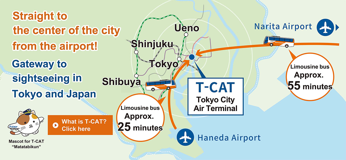
T-CAT offers convenient access to a variety of accommodation options in the area. Staying near T-CAT can be beneficial for travelers who prioritize efficient airport transfers.
Taxis in Tokyo are readily available, whether you hail one on the street or find them at designated stands. While convenient, especially for late-night travel or transporting heavy luggage, taxis are generally more expensive than public transportation. Fares are calculated based on distance and time, with a base fare and additional charges per kilometer. A night surcharge applies from 10 PM to 5 AM. Unlike many other countries, tipping is not customary in Japan. Many taxis in Tokyo now accept Suica and other IC cards, but it's still a good idea to check if the taxi you're about to board accepts IC cards before getting in.
For example, a daytime trip from Ginza to Shibuya, approximately 6 kilometers, would typically take around 20 to 30 minutes by taxi and cost between ¥2,000 and ¥3,000. If Shutoko Highway is used, a toll of ¥480 can be added. In comparison, taking the Ginza subway line for the same journey would cost ¥210 and take about 15 minutes.
Google Maps is an invaluable tool for navigating Tokyo, but its limitations can hinder a smooth journey. While it offers various routes, it often prioritizes speed over simplicity, leading to complex itineraries with multiple transfers. Navigating intricate stations like Tokyo Station can be challenging due to limited multi-floor functionality. Moreover, Google Maps often fails to provide specific entrances and exits of subways or underground passages and, more importantly, sometimes subway stations, which are crucial for efficient travel. This is how Google Maps displays when searching “Otemechi Stations.” Actually, there are five Otemachi Stations - Tokyo Metro Tozai, Chiyoda, Marunouchi, Hanzomon Line Stations, and Toei Chikatetsu Mita Line’s Otemachi Station as shown. Many subway stations serve more than two subway lines, so you need to pay attention to which gate you enter for your line. Also, when exiting a station, choosing the right exit is important to reach your destination without wasting time. To overcome these challenges, travelers should complement Google Maps with local transit apps, official station maps, and on-site signage.
Despite these limitations, Google Maps and other apps remain very helpful for navigating Tokyo’s transit system, and a stable digital connection is essential for using these apps effectively. For international travelers, eSIMs offer flexibility and cost-effectiveness, though they may not be compatible with all smartphones. In such cases, a pocket Wi-Fi device is advantageous, especially for families, as it provides a shared internet connection. For smartphones incompatible with eSIMs, renting a SIM card is a reliable alternative.
While many people in tourist areas speak some English, speaking clearly and slowly is essential. In addition to using Google Maps, having Google Translate handy can make a significant difference, making your interactions smoother and more confident. Google Translate bridges language gaps by translating text, signs, and menus using your phone’s camera, and it also offers voice translation for real-time conversations.
Open your Google Translate app and tap the microphone icon. Speak the phrase, "Can you recommend a good restaurant nearby?" The app will then provide a Japanese text translation. Tap the speaker icon to have your phone pronounce the translated phrase.Very simple, isn’t it?
With a solid grasp of Tokyo’s transportation network and effective use of tools like Google Maps and Translate, your visit will be smooth and rewarding. Tokyo boasts a rich culture and efficient transit system. By mastering public transportation, leveraging essential apps, and staying connected, you'll be well-prepared to fully immerse yourself in this captivating city.
Mastered Tokyo transit? Great! Share your tips in the comments. Don't forget to like and subscribe for more episodes of A Passage to Japan's Wonders.
